400,000 BC
The island of Saba is the top of a volcano that became active during the middle or late Pleistocene era. Saba is technically a dormant volcano but has not erupted for about 5,000 years. However, there are traces of pyroclastic flows from the 17th century.
Circa 1175 BC
Hunter- gatherers called the Ciboney, are the earliest settlers on Saba. They lived near Fort Bay where recent radiocarbon samples show that the settlement site is over 3,000 years old.
Circa 800 AD
The Arawak Indians migrated into the Caribbean basin from South America and built villages on Saba. They took shelter in caves and many artifacts including pottery, shell tools, and carved stone tools have been found in the Spring Bay area. The Carib Indians were also on Saba, but the Arawak’s probably preceded the Caribs and survived their onslaught.
Circa 1493
Christopher Columbus sighted Saba but sailed on by without attempting any sort of landing due to the treacherous nature of the jagged volcanic shores. Saba remained part of the Spanish Empire for almost 150 years until 1627 when French Adventurers arrived Later in 1629, English pirates started exploring all the Caribbean islands for settlements.
Circa 1632
The island welcomed the first European visitors, a group of shipwrecked Englishmen, they reported later that the island was inhabited. Recently found artifacts revealed the existence of Amerindian settlements.


Circa 1640
The Dutch West Indian Company, which had already settled on the neighboring island of St. Eustatius (known then as “The Golden Rock” as it was thriving regional center of commerce) brought people over to Saba to colonize the island. Soon after, those Dutch men were chased away by the famous British pirate Henry Morgan, due to the ongoing conflict between the Netherlands and Britain.
For almost 200 years the island changed hands between the Dutch, Spanish, French, and English. During this period the Bottom was the first established village on Saba. Situated 1200 feet above Fort Bay, the village is now the administrative center and capital of Saba.
Circa 1816
Although most Sabans are descendants of the English and Irish, it was Holland that finally took possession of Saba. Like everywhere else in the Caribbean, the tragedy of slavery brought people of African descent to Saba’s shores, because life on the island was hard and all had to work together to survive, slavery on Saba ended far in advance of other parts of the world.
During the early to mid-1800’s, most of the male population went to sea and became highly skilled fishermen and seamen. They were often gone for so long that Saba became known as the “Island of Women.” For many years Saba was known as a haven for Caribbean pirates, including the famous Hiram Beakes who once quipped “Dead men tell no tales”. Until well into the 20th century, most men fished or sailed on Saban vessels all over the Caribbean. They brought much needed money to the local economy. Others farmed plots of land on the mountain slopes, where conditions were suitable for agricultural activity.
Circa 1884
With most of the men away from the island, Saba’s women became very resilient and independent by necessity. Their renown grew for making socks, shoes, belts, gloves, Panama style straw hats and what is now known a Saba Lace.
Originally known as Spanish Work, Sabans made it their own and Saba Lace is still created and can be purchased in several locations around the island today.
Circa 1887
The McNish Sulphur Mining Company begins mining on Saba, employing over 100 Sabans. However, the mining venture ended within a year. The mine and the sulfur oven still exist.


The Twentieth Century
In 1909 A navigational school was established by Frederick Simmons to train young Saban men in the ways of the sea.
Until 1943, transportation on Saba was not easy, steep trails between the sea and the settlements on the hills were negotiated on foot and donkey. Finally, in 1943, Josephus "Lambee" Hassell achieved the road that, Dutch & Swiss engineers claimed, "couldn't be built". Hassell simply took a correspondence course in civil engineering and started to build the road with the help of his fellow islanders. Between 1943 & 1958 the road was completed in stages, the final stage being the road to Flat Point the future location of Saba's airport.
The first aircraft landing was in 1959 and an airport was opened in 1963 linking the island to St. Maarten. Finally, the construction of a pier in 1972 allowed not only fishing boats but also sailboats and dive boats to moor, thus opening up the island to the possibility of tourism. It wasn't until the late 80's that Saba's Tourism industry started to grow.
The Saba Conservation Foundation (SCF) is a non-profit, non-governmental organization (NGO) and was established in 1987, with the main objective of preserving and managing Saba’s Natural and cultural heritage. As previous generations of Saba people had appreciated the island’s natural resources, the SCF was not conceived to repair damaged habitats, but rather to ensure the continued quality of an extraordinary environment for the benefit and enjoyment of all.


The Twenty-First Century
Formally part of the Netherlands Antilles, Saba became part of a special municipality of the Kingdom of the Netherlands together with the islands of St. Eustatius and Bonaire in 2010.
Today Saba's guests will discover a mixed population of European, African and Latin descendants, speaking English, Dutch and Spanish. Saban houses are well kept, the gardens team with flowers and the doors seldom are locked. The friendliness of Sabans is not in any doubt, and everyone knows everybody on the Unspoiled Queen.
Saba's Road
It's fair to say that not many places in the world can boast a road as an attraction. The Saba people challenge you to take a 30-minute drive on ‘The Road’ to understand why Saba lives up to its nickname: “The Unspoiled Queen”.
Buckle up when you depart Saba’s renowned airport and enter Zion's Hill (A.k.a. Hell’s Gate). As you wind and twist the chiseled cliff sides you may struggle to focus on the amazing panoramas of the neighboring islands, old fashion villages and varied seascapes. As you carve your way across the island, down the S-curve (pictured above and below), you find Saba’s point of commerce–it's only harbor–Fort Bay. Engage first gear to get back up to The Bottom (at 1,200 feet) in order to get down to your next stop, the elusive disappearing, reoccurring beach at Well's Bay.
Before The Road life on Saba was much tougher, Sabans faced the arduous task of traversing the island by trail, everything including the kitchen sink, pianos and monarchs were transported by hand and donkey through grueling elevations beneath the unforgiving Caribbean sun on twisting trails. In the late 1930's the decision to build a concrete road was made. Dutch & Swiss Civil Engineers deemed it a foolhardy task due to the island's extreme topography. Thus The Road got its title: "The Road that couldn't be built."


Building "The Road that couldn't be built".
Josephus Lambert Hassell (A.k.a. Lambee) Luckily for the island it was left to a Saban to make the much-needed piece of infrastructure a reality. Josephus was a man who had issues with the word "couldn't". Challenged by the word he studied civil engineering by way of correspondence courses through the mail. In 1938, with the assistance of his fellow Sabans and no heavy machinery (yes it was all built by hand!) they got down to the business of the impossible. The vital access road from Fort Bay to The Bottom was completed within 5 years. This first stage of The Road was inaugurated in 1943. Four years later the first motor vehicle arrived.
In 1951, The Road to Windwardside and St. John's was opened and seven years later The Road was completed. For two decades the islanders toiled to complete the project. Exercise caution before using the word “never” or the phrase "it can’t be done" within earshot of a Saban.
Driving The Road is an experience in itself. On your journey, a plethora of ecological zones await. Meandering from dry scrubland up to dense tropical vegetation, winding past many steep drop-offs as you go, the views are spectacular. Ascending the "Mountain Road", which ends at the Mt. Scenery trail, brings you to the highest point of The Road which is over 1800 feet above sea level. Don't be surprised while driving (or being driven) on Saba, to slip from bright warm sunshine into the cool mystical cloud.
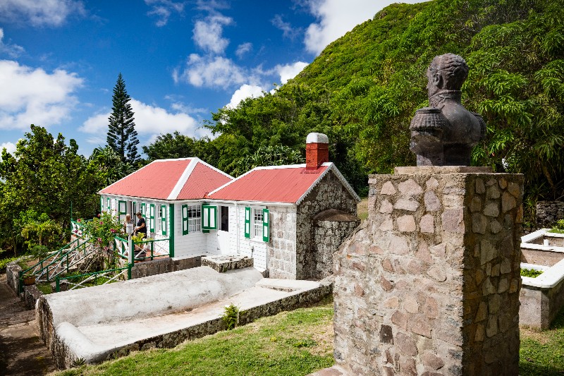
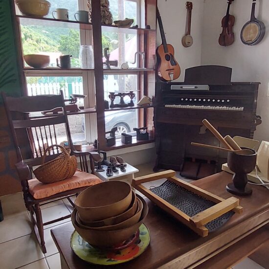
Museums on Saba