
Explore Saba's 20 hiking trails
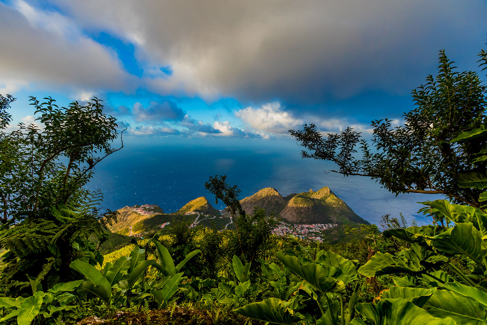
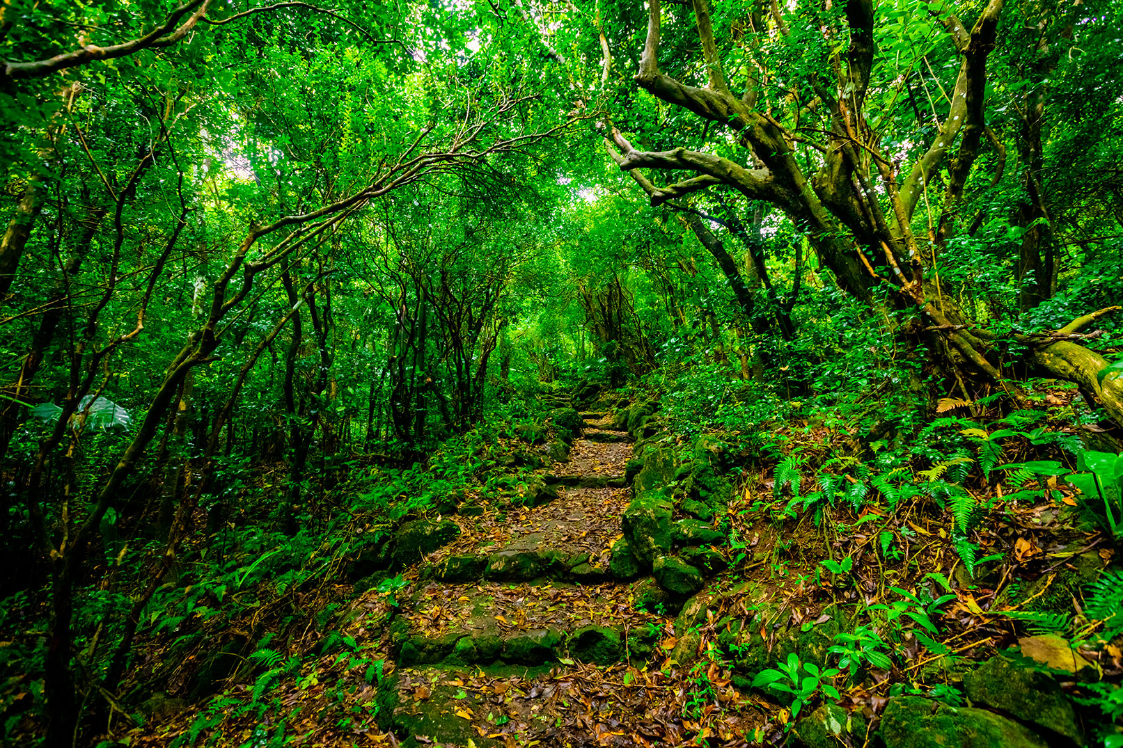
Hiking on Saba offers a truly rewarding experience, showcasing a diverse and unique natural landscape that rivals the beauty beneath its waters. The island’s vegetation changes dramatically with altitude and rainfall, creating distinct ecological zones. At the summit of Mt. Scenery, you're often surrounded by mist, creating a lush cloud forest. Slightly lower, you'll encounter vibrant rainforest vegetation, while descending further reveals drier, more arid environments as the humidity lessens. Near the coast, plants and trees have evolved to thrive in the salty, rugged conditions, making each step of your hike a journey through varied and fascinating ecosystems.
With 20 well-maintained hiking trails, Saba offers something for every level of adventurer. Whether you're looking for a challenging climb or a leisurely walk, there's a trail that will immerse you in the island’s natural beauty. Lace up your boots and start exploring!

Top 5 Trails you shouldn't miss!
1. Mt Scenery
Difficulty: Strenuous - Time: 1½ hours (one-way)
Tackle the Mount Scenery trail on Saba for a rewarding adventure through a mystical cloud forest. With 1,064 steps leading to the highest point in the Dutch Kingdom, you'll be greeted by sweeping Caribbean views and lush, exotic landscapes. A perfect blend of challenge, beauty, and serenity!


2. Sandy Cruz Trail
Difficulty: Moderate - Time: 2½ hours (one-way)
Embark on the Sandy Cruz Trail on Saba for a stunning journey through diverse ecosystems. This moderate hike takes you along a scenic ridgeline, where you'll be rewarded with breathtaking views of the Caribbean Sea and the island’s lush interior. Experience vibrant flora and fauna while enjoying the serenity of nature. Perfect for those seeking beauty and adventure in one unforgettable hike!
3. Tidepools
Difficulty: Easy - Time: 25 minutes (one-way)
Explore the Tide Pools trail on Saba for a delightful coastal adventure. This short, easy hike leads you to unique tidal pools teeming with marine life and offers spectacular ocean views. As you navigate the rocky shoreline, you'll witness the beauty of Saba’s coastline and the vibrant ecosystems that thrive in these natural pools. It’s an ideal spot for families and nature lovers alike!


4. The Ladder
Difficulty: Moderate - Time: 30 minutes (one-way)
Challenge yourself on The Ladder trail, a historic route that connects Saba’s rugged coast to its mountainous interior. Climbing 800 steps carved into the rock, this steep ascent offers breathtaking views of the coastline and the surrounding sea. As you ascend, discover the history behind this iconic path, once vital for transporting goods. It’s a unique blend of adventure, history, and stunning scenery!
5. Crispeen Trail
Difficulty: Moderate - Time: 1 hour (one-way)
Discover the beauty of the Crispeen Trail on Saba, where lush forests and scenic lookouts await. This moderate hike takes you through tropical vegetation, offering a peaceful escape into nature. Enjoy the vibrant plant life and occasional panoramic views of the island as you wander along this path. Perfect for those seeking tranquility and a chance to immerse themselves in Saba's natural splendor!

Hiking Preparation: Gear, Safety, and Best Practices
1. Recommended Gear
- Sturdy hiking boots
- Comfortable, weather-appropriate clothing
- Hiking poles (optional)
2. Essentials to Bring
- Plenty of water
- Snacks
- A map (available at the trail shop)
3. Inform others of your hiking plans
- Many of the hiking trails on Saba have limited or no mobile coverage, making it crucial to inform someone about your plans before you head out. Let them know your intended route and estimated return time, ensuring they can assist you if necessary. This simple precaution enhances your safety and peace of mind while exploring the island's beautiful but remote landscapes.
4. Check the Latest Trail Advisory before heading out
- The trail advisory by SCF contains information about trail conditions, descriptions, and any warnings you should know about.
- Click here to see the latest Trail Advisory
5. Read the Trail Etiquette

Guided Hikes

The Trail Shop is located at the foot of the Mt. Scenery Trail in the village of Windwardside. If you’re planning on hiking, stop here first for information and tips on getting the most out of your Saba expedition. Your hotel will collect a $1 nature fee per night for trail upkeep, and guests can pick up a whistle at the Trail Shop. Trail maps, various gifts, books and souvenirs can be purchased here.
For guided hikes, visitors can call the Saba Conservation Foundation at +599 416 3295 or book their guided hike online. Guided hikes on the North Coast Trail have been stopped due to erosion along the trail.
About Saba's Nature
The Summit of Mt. Scenery
Mt. Scenery is the highest point in the Dutch Kingdom (877m or 2877ft) and is Saba’s dominant feature. Dense vegetation with a variety of species covers the summit and upper slopes. The Elfin Forest (cloud-forest) dominates the upper 50m (150ft) of the mountain and is comprised of Mountain Mahogany covered with Epiphytes, Orchids and a myriad of other unique and rare plants.
Lower slopes
Just below the summit, Mountain Palms, Tree Ferns, Elephant Ears and Heliconias dominate.
Secondary rainforest and dry evergreen forests are found lower down on the slopes. Species in this zone include Redwood, Sea Grape, White Cedar and Turpentine trees as well as Cacti species such as the Prickly pear. Closer to the sea, grassy meadows with scattered shrubs predominate. Steep cliffs and bluffs can be seen throughout the island with several sheer walls rising over 100m (330ft). Due to its rugged terrain, Saba does not have typical Caribbean beaches but there are several sandy bays that change with the prevailing ocean swells.
One of the shorter hikes in Saba is the climb down to the Tide Pools at Flatpoint. It’s one of the few hikes that doesn’t take you through one of the different types of forest on the island as it is located at the coast of the island. The tide pools are small enclosures between cliffs and rocks which are filled with seawater and are the end product of an ancient lava flow. Here you have dramatic views of the Caribbean Sea and the northeast side of the island. At certain times there is a rip current warning, because of incoming waves which can be very dangerous. Check with the Trail Shop before heading out on any hike for updated information on conditions and closures.
Flora and Fauna
Saba’s plant and animal life is a mixture of native and introduced species. This occurred hundreds of years ago and it is very difficult for the average tourist to tell the difference today. Mango, banana, Black-Eyed Susan, tree frogs, goats and chickens were all brought to the island. Some of our endemic species are the Saban Anole lizards (found only on Saba), Green Iguanas and Red-Bellied Racer Snakes (completely harmless).
Saba is home to over sixty species of birds, many of which are seabirds. Bridled Terns, Sooty Terns and Brown Booby birds breed every year in late spring on Green Island. Red-Billed and White-Tailed Tropicbirds nest in the high cliffs while Frigate Birds and Brown Boobies soar near the coast. Other feathered visitors include the Common Ground-Dove, Bridled Quail Dove, Red-tailed Hawks, Thrashers, Hummingbirds and Bananaquits.
Visit the Tide Pools to get a spectacular view of marine life in the crystal clear water, including; different types of sea urchins, little colorful fish and sea flora.